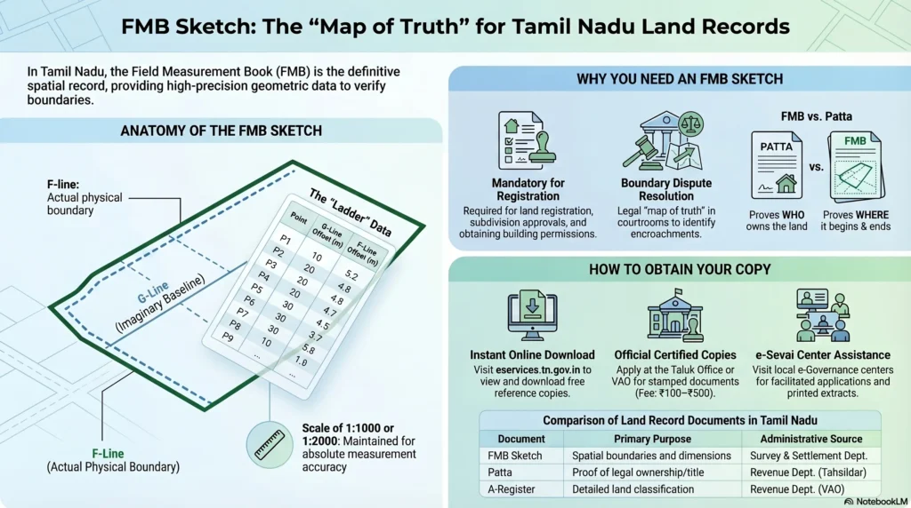
When buying land in Tamil Nadu, property boundaries on the ground are confirmed through the FMB Sketch, an essential yet frequently overlooked land record. FMB stands for Field Measurement Book, and it contains detailed survey drawings that determine the precise shape, measurements, and boundary lines of land parcels. Maintained by the government at the Village Administrative Office (VAO) or Revenue Department, these sketches are typically drawn at scales of 1:1000 or 1:2000.
What is an FMB Sketch and Why is it Important?
An FMB Sketch is an official, scaled field drawing prepared by the Tamil Nadu Survey Department based on physical ground measurements. It records the shape, dimensions, adjacent survey numbers, and nearby features like pathways or water bodies.
While a Patta confirms who owns the land, the FMB sketch confirms the physical truth of the land itself. It is critical for:
- Demarcating land boundaries before registration.
- Resolving boundary disputes between neighbors.
- Verifying layout approval claims and supporting DTCP/CMDA building permissions.
- Detecting overlaps into Open Space Reservation (OSR) land, water bodies, or government (poramboke) areas.
- Establishing undivided share (UDS) in apartment complexes.
Key Components of a Tamil Nadu FMB Sketch
A standard Tamil Nadu FMB sketch uses a standardized set of geometric lines and symbols to map the terrain accurately.
The G-Line and F-Line
- G-Line (Grid Line): This is an imaginary baseline that outlines the making of the entire sketch. It converts the sketch into different sizes of triangles to fix boundary lines and points. Any errors in the G-line can impact all essential computations in the sketch.
- F-Line (Field Line): This designates the actual field boundaries on the outer lines of the sketch. The points on the F-line are fixed based on their offset distance from the imaginary G-line.
Subdivision Lines, Ladders, and Extension Lines
- Subdivision Lines: These define smaller, restricted areas within a main survey number. They are typically presented through a ladder.
- Ladder: The ladder provides the distance offset from the G-line, highlighting left or right angle deviations. Converting ladder details into digital data helps recreate the actual outline of the FMB sketch.
- Extension Lines: These lines show the exact direction in which the subject field meets neighboring fields, ensuring clarity and continuity with the overall village map.
- Neighboring Field Survey Numbers: Every FMB indicates the surrounding field numbers, which is necessary for converting FMBs into D-sketches and cross-referencing adjacent plots.
How to Access and Download Your FMB Sketch
You can obtain your FMB sketch through digital portals or manual requests, depending on whether your local records have been digitized.
Step-by-Step Online Process (TN e-Services)
The Tamil Nadu government offers free downloads of digitized FMB sketches.
- Visit the official TN e-Services portal at
eservices.tn.gov.in. - Click on the option for “View Patta & FMB / Chitta / TSLR Extract”.
- Select your area type (Rural or Urban).
- Submit the required details, enter the authentication value, and download the sketch.
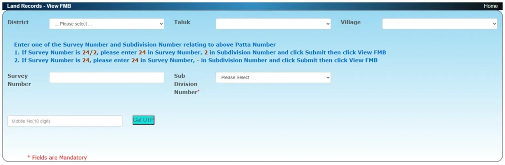
Information Needed for Online Download
To access the record online, you must select your:
- District
- Taluk
- Village (or Town/Ward/Block for urban areas)
- Survey Number and Subdivision Number
Offline Process (Taluk Office or VAO)
Not all villages have digitized FMBs. If your sketch is unavailable online, or if you need a certified copy for legal purposes, you must apply offline:
- Visit the Taluk Office or VAO covering your property.
- Submit a written request providing your property details (Survey Number, Village, Taluk).
- Attach a copy of your Patta, Sale Deed, and an identity proof like an Aadhaar card.
- Pay the prescribed processing fee, which generally ranges from ₹100 to ₹500.
- The certified copy is typically processed and issued within 3 to 7 working days.
FMB Sketch vs. Patta vs. A-Register
It is crucial not to confuse the FMB with other revenue records, as each serves a distinct legal purpose:
- FMB Sketch: Shows the precise physical dimensions, measurements, and boundary lines of a single plot. It is the “gold standard” for knowing how much land physically exists.
- Patta: Proves the current legal ownership of the land and is used as title proof.
- A-Register: Contains the historical classification of the land (e.g., wetland, dry land, commercial, poramboke), total extent, original recorded owner, and tax assessment.